I have spent over fifteen years exploring California’s backroads, and I can tell you this: the Golden State holds secrets that most visitors never discover. While crowds flock to the Hollywood sign and Golden Gate Bridge, I’ve found myself alone at waterfalls cascading onto beaches, inside abandoned silver mines, and wandering through deserts painted with technicolor art.
These hidden gems in California offer something the famous attractions cannot – authentic experiences without the tourist crush. Whether you are planning a California road trip or seeking family-friendly vacation spots in California, this guide reveals the lesser-known places that make this state truly special.
I have organized these discoveries by region, included practical visiting information you will not find elsewhere, and added insider tips from years of exploration. Let me show you the California that locals keep to themselves.
Table of Contents
Quick Picks – 5 Must-See Hidden Gems in California
If you only have time for a few stops, these five spots deliver the most unique experiences per mile traveled. I have visited each location multiple times across different seasons.
- Salvation Mountain – Leonard Knight’s labor of love in the desert near Niland, this 50-foot tall mountain covered in painted biblical verses offers an unforgettable roadside attraction that costs nothing to visit.
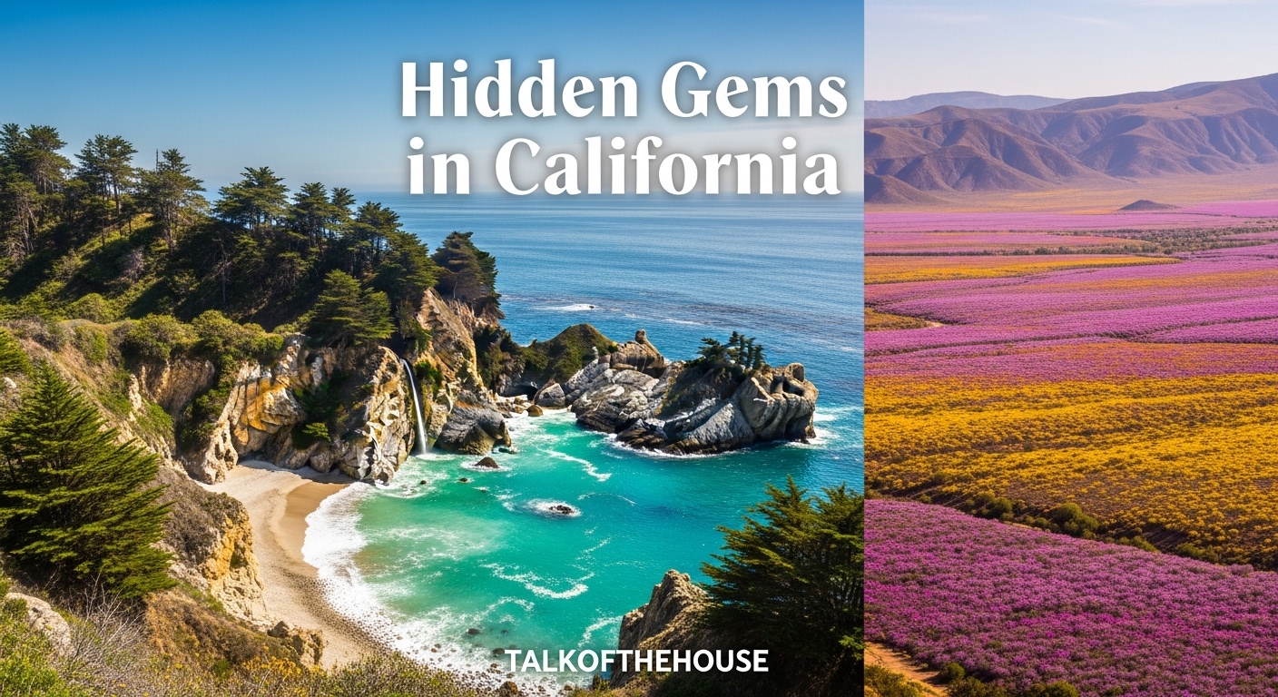
- McWay Falls – An 80-foot waterfall that drops directly onto a pristine beach in Big Sur. The half-mile trail delivers maximum payoff for minimal effort, making it perfect for all fitness levels.
- Bodie State Historic Park – The most intact ghost town in America sits at 8,379 feet in the Eastern Sierra. Over 100 buildings remain exactly as left in the 1940s, including a general store with original merchandise still on shelves.
- Fern Canyon – Located in Prairie Creek Redwoods State Park, this narrow canyon features walls covered in seven types of ferns. Steven Spielberg filmed scenes from Jurassic Park 2 here because the location looks prehistoric.
- The Integratron – A white dome in the Mojave Desert built in the 1950s supposedly on a geomagnetic vortex. Today it offers sound bath experiences using quartz singing bowls that create vibrations you feel in your bones.
Hidden Gems in Northern California
Northern California stretches from the Oregon border down through the redwood forests and into the Sierra Nevada mountains. This region holds some of the state’s most dramatic natural wonders, yet many visitors rush through on their way to more famous destinations.
The forum discussions I reviewed showed constant requests for recommendations in this area. Redditors specifically asked about “hidden gems in NorCal that tourists don’t know about.” Here are the places I return to again and again.
Glass Beach and Coastal Treasures (Fort Bragg)
Once a city dump site, Glass Beach in Fort Bragg now glitters with sea glass created from decades of discarded bottles worn smooth by Pacific waves. I first visited at sunrise and had the entire shoreline to myself. The beach catches morning light in ways that make the colored glass fragments glow like scattered jewels.
MacKerricher State Park surrounds Glass Beach with additional discoveries. Pudding Creek Trestle offers a dramatic wooden railway bridge that extends over the ocean. The Point Cabrillo Light Station nearby provides one of the most photographed lighthouse scenes on the West Coast, yet receives far fewer visitors than Point Reyes or Pigeon Point.
Practical Information: Parking at Glass Beach costs $8 per vehicle at MacKerricher State Park. Morning low tide exposes the most sea glass. Spring and fall offer the clearest skies without summer fog. The town of Fort Bragg provides excellent seafood restaurants – I recommend the chowder at North Coast Brewing Company after your beach walk.
Fern Canyon – Where Jurassic Park Was Filmed
About six hours north of San Francisco, Fern Canyon lives up to its prehistoric reputation. Vertical walls rise 50 feet on either side, completely covered in ferns that drip with moisture even during dry summer months. The canyon floor requires wading through shallow streams, so bring waterproof boots or sandals you do not mind getting wet.
I visited in late May when the ferns reached peak green vibrancy. The filtered light creates a cathedral-like atmosphere that photographs beautifully but feels even more impressive in person. Home Creek flows through the canyon year-round, keeping the ecosystem lush even during California drought years.
Practical Information: Access requires driving eight miles on Davison Trail, a narrow dirt road passable by most vehicles in dry conditions. Arrive before 10 AM to secure parking – only 25 spaces exist at the trailhead. The one-mile loop through the canyon takes about 90 minutes including photography stops. Roosevelt elk frequent the nearby meadows at dawn and dusk.
Lassen Volcanic National Park’s Bumpass Hell
Most California visitors never hear about Lassen Volcanic, the state’s least visited national park. Within its boundaries lies Bumpass Hell, a geothermal basin named after explorer Kendall Bumpass who lost his leg here when the crust broke beneath him in 1865.
The three-mile round-trip hike leads to boardwalks suspended over bubbling mud pots, steaming fumaroles, and pools of boiling turquoise water. The sulfur smell hits you before the visual spectacle does – bring a bandana if you are sensitive to strong odors. I found the experience rivaled Yellowstone’s famous geothermal features without the crowds.
Practical Information: The trail opens seasonally, usually from July through October depending on snowpack. No entrance fee beyond the $30 park admission. Sturdy hiking boots recommended – the trail crosses rocky terrain. The best lighting for photography occurs in late afternoon when steam becomes visible against shaded areas.
Old Shasta and Whiskeytown Falls
Near Redding, the ruins of Old Shasta stand as a reminder of California’s second Gold Rush boom town. The brick buildings that remain survived fires that destroyed the wooden structures in 1853. I walked through the former courthouse and general store, reading interpretive signs that brought the 1850s to life.
Whiskeytown National Recreation Area nearby contains a 220-foot waterfall that most visitors miss entirely. Whiskeytown Falls requires a 3.4-mile round-trip hike with 700 feet of elevation gain. The trail opened to the public in 2004 after being privately held for decades. I reached the falls in late afternoon and had the viewing platform to myself.
Practical Information: Old Shasta State Historic Park charges no admission fee. Whiskeytown Falls trailhead parking requires a $5 day pass. Spring offers the strongest water flow. The nearby town of Weaverville holds a preserved Chinese Taoist temple from the Gold Rush era – another hidden gem worth visiting.
Hidden Gems in Central California
The central coast between Monterey and San Luis Obispo contains some of California’s most photographed scenery, yet most tourists stick to the famous spots along Highway 1. I have found the real magic happens when you pull over at unmarked turnouts and explore trails without trailhead signs.
This region rewards slow travel. My best discoveries came from chatting with locals at coffee shops in Cambria and San Simeon, who pointed me toward beaches that do not appear on maps.
McWay Falls – The 80-Foot Waterfall That Drops Onto the Beach
Julia Pfeiffer Burns State Park protects this iconic waterfall that pours directly onto an inaccessible beach below. The overlook trail provides the only legal viewing point, but the perspective captures the full drama – a ribbon of water tumbling 80 feet onto pristine sand with turquoise ocean beyond.
I photographed McWay Falls during golden hour when the setting sun illuminated the waterfall from behind, creating a glowing effect. Winter storms increase the water flow dramatically compared to late summer trickles. The beach below remains closed to protect fragile habitat, but the view from above satisfies completely.
Practical Information: Located 37 miles south of Carmel on Highway 1. The park charges $10 per vehicle. The waterfall trail measures only 0.6 miles round-trip on paved paths accessible to wheelchairs and strollers. Arrive before 9 AM or after 4 PM to avoid tour bus crowds. No dogs permitted on the trail.
Pfeiffer Beach’s Purple Sand
South of Big Sur village, an unmarked road leads to Pfeiffer Beach where manganese garnet deposits create patches of purple sand mixing with regular golden grains. The effect intensifies after winter storms wash fresh deposits down from surrounding hillsides.
Keyhole Rock dominates the beach – a massive stone arch that frames sunset photos perfectly between December and January when the sun aligns precisely with the opening. I spent three evenings waiting for perfect light and finally captured the sunbeams shining through the arch on my last night.
Practical Information: The turnoff from Highway 1 sits two miles south of the post office in Big Sur – watch for Sycamore Canyon Road (unmarked but shows on GPS). The narrow two-mile descent requires careful driving. Parking costs $15 per vehicle. The beach allows dogs on leash. Winter visits offer the strongest purple sand concentrations.
The Cypress Tree Tunnel at Point Reyes
On the road to the historic RCA radio station at Point Reyes, a tunnel formed by Monterey cypress trees planted in 1930 creates one of California’s most photographed natural corridors. The trees bend inward from both sides, forming a Gothic archway that frames the white building at the end.
I arrived at sunrise on a foggy morning and watched the scene transform as golden light pierced through marine layer clouds. The effect lasted only twenty minutes before harsh midday lighting took over. This spot exemplifies how timing transforms an already beautiful location into something magical.
Practical Information: Located at the end of Sir Francis Drake Boulevard, 45 miles north of San Francisco. No fee required. The tunnel sits before the paid parking area for Point Reyes Lighthouse, making it free to visit. Morning fog common from June through September – check weather forecasts for clear conditions if you want sunbeams through the trees.
Hidden Gems in Southern California
Southern California’s reputation for crowds and traffic disappears when you know where to look. The deserts east of San Diego and Los Angeles hold surreal landscapes that feel imported from another planet entirely. I have spent weeks exploring these otherworldly places.
The forum posts I analyzed frequently mentioned “LA hidden gems” and “secret spots” that locals wanted to protect from over-tourism. I am sharing these carefully, emphasizing that responsible visitation helps preserve these places for future explorers.
Salvation Mountain – A Man-Made Wonder in the Desert
Leonard Knight spent 28 years painting biblical messages on a desert hillside using adobe, straw, and thousands of gallons of donated paint. The result stands 50 feet tall and 150 feet wide – a riot of color against the beige Mojave landscape. Knight lived on site without electricity or running water until his death in 2014.
I walked the yellow brick road path to the top of the mountain, reading the painted scripture verses and admiring the folk art aesthetic. The site operates under constant threat of weather damage and requires volunteers for maintenance. Despite appearing in music videos and films, it remains relatively uncrowded due to its remote location near the Salton Sea.
Practical Information: Located in Niland, California, about 1.5 hours from Palm Springs. Free admission, though donations support preservation. Visit early morning or late afternoon – midday summer temperatures exceed 115 degrees. Bring water as no services exist on site. The adjacent Slab City community offers additional artistic exploration.
Bombay Beach at the Salton Sea
The Salton Sea, California’s largest lake, formed accidentally in 1905 when irrigation canals flooded the desert basin. Today it is slowly evaporating, leaving behind abandoned resorts, rusted trailers, and beaches composed of fish bones from mass die-offs. Bombay Beach represents the most accessible entry point to this post-apocalyptic landscape.
Artists have reclaimed the decaying town, installing installations among the ruins. I walked past the Bombay Beach Opera House, a half-submerged structure where performances still occur, and found myself alone on salt-encrusted shores that stretched to the horizon. The area attracts photographers seeking moody, abandoned Americana aesthetics.
Practical Information: Located on the eastern shore of the Salton Sea, 2.5 hours from Los Angeles and 1 hour from Palm Springs. Free to explore. Summer heat makes visiting nearly unbearable – plan trips between October and April. The lake smell can be strong depending on wind direction. The nearby town of Niland provides the closest food and fuel.
The Integratron Sound Bath in Landers
George Van Tassel began constructing this white dome in 1954 after claiming contact with extraterrestrials who provided instructions for a rejuvenation machine. Though Van Tassel died before completing his intended purpose, the structure now hosts sound bath experiences using quartz singing bowls that create harmonic frequencies.
I participated in a 60-minute sound bath session and emerged feeling genuinely altered. The acoustics inside the all-wood dome create sensations you feel physically as sound waves resonate through your body. Whether you believe in the claimed healing properties or not, the experience itself proves memorable.
Practical Information: Located in Landers, 20 miles north of Joshua Tree. Sound bath sessions cost $35-50 per person and require advance booking through their website. The site sits on several acres of desert with no shade – arrive shortly before your appointment time. Children under 12 not permitted in sound baths. Gift shop sells singing bowls and related items.
Pioneertown – The Old West Movie Set You Can Visit
In 1946, actors Roy Rogers, Gene Autry, and others built an entire Old West town as both a movie set and living community. Pioneertown’s Mane Street looks like a classic Western town with wooden sidewalks, false-front buildings, and a functioning bowling alley that dates to the original construction.
I visited on a weekday when film crews were not present and wandered through the unpaved streets feeling transported to the 1880s. Pappy and Harriet’s Pioneertown Palace, opened in 1982, serves excellent BBQ and hosts live music nights that draw crowds from Palm Springs. The contrast between the frontier aesthetic and modern concertgoers creates amusing juxtapositions.
Practical Information: Located 4 miles west of Yucca Valley, 20 minutes from Joshua Tree National Park. Free to walk Mane Street. Pappy and Harriet’s requires reservations for dinner, especially on weekends when concerts occur. The town hosts reenactment events periodically – check their calendar. Best visited in combination with Joshua Tree for a full day trip.
Ghost Towns and Abandoned Places
California’s Gold Rush created hundreds of boom towns that collapsed when the ore ran out. Some vanished completely while others remain partially preserved. I have a particular fascination with these frozen moments in time.
These sites require respect – taking artifacts or damaging structures removes history forever. I practice “leave no trace” principles even more strictly at abandoned locations than in wilderness areas.
Bodie State Historic Park – The Best Preserved Ghost Town in America
At 8,379 feet elevation in the eastern Sierra, Bodie preserves over 100 structures exactly as left in the 1940s when the last residents departed. The state park maintains the town in “arrested decay” – preventing further deterioration without restoring buildings to new condition.
I peered through windows of the Boone Store and Warehouse seeing original merchandise still on shelves – canned goods, fabric bolts, hardware supplies. The Methodist church retains its pews and organ. An antique car rusts in a garage. The effect feels like stepping into a post-apocalyptic world where everyone vanished simultaneously.
Practical Information: Open year-round, though winter access requires snow vehicles. Located 13 miles east of Highway 395 on a rough dirt road. Entry costs $8 per adult, children free. No services on site – bring water, food, and fuel. The nearest town with amenities is Bridgeport, 22 miles north. Guided tours available through the Bodie Foundation.
Cerro Gordo – The Silver Mining Town Above Death Valley
Perched 8,500 feet above Owens Valley, Cerro Gordo produced $500 million worth of silver and lead between 1865 and 1957. The town included 4,000 residents at its peak with 37 saloons, a red-light district, and a murder every week on average. Today a single caretaker lives on site, and the current owners are slowly restoring buildings for limited overnight stays.
I visited during one of their monthly open houses and walked through the American Hotel, built in 1871 and the oldest standing hotel in California. The old bunkhouse, assay office, and hoisting works remain intact. Views from the town overlook the Alabama Hills and Sierra Nevada range, with Death Valley visible beyond.
Practical Information: Located 8 miles up a steep, narrow dirt road from Lone Pine. High clearance vehicles required – no sedans or low-profile cars permitted. Open only during scheduled tours or with overnight reservations through their website. Day visits cost $25 per person. No food service on site. Weather changes rapidly at this elevation – bring layers even in summer.
Tips for Finding Your Own Hidden Gems in California
After years of exploring, I have developed strategies for discovering places that do not appear in guidebooks. These techniques have led me to abandoned hot springs, secret waterfalls, and pristine beaches without footprints.
- Talk to Locals at Coffee Shops – Baristas in small towns hear every conversation about local attractions. I mention I am interested in photography and hiking, then ask what spots they recommend that tourists miss. This approach has never failed me.
- Search Instagram Geotags Before They Become Famous – Locations often appear on Instagram months before mainstream travel sites discover them. I search geotags in areas I plan to visit and look for consistent posting patterns that indicate accessible places worth visiting.
- Buy the DeLorme Atlas – This detailed paper atlas marks unpaved roads, springs, and historic sites that GPS often misses. I have found numerous waterfalls and abandoned cabins by following old forest service roads shown on these maps.
- Visit During Shoulder Seasons – September through November and April through June offer perfect weather with fewer crowds. I visited Big Sur in October and had McWay Falls almost entirely to myself, whereas July visits meant sharing the viewpoint with fifty other people.
- Check Road Conditions Before Desert Trips – Flash floods destroy roads in desert areas. I always verify conditions with ranger stations before attempting remote desert locations, especially near Death Valley and Mojave National Preserve.
Frequently Asked Questions
What are California’s best hidden gems?
California’s best hidden gems include Salvation Mountain in the Mojave Desert, McWay Falls in Big Sur, Bodie State Historic Park ghost town, Fern Canyon in Prairie Creek Redwoods State Park, and Glass Beach in Fort Bragg. These locations offer unique experiences away from crowded tourist destinations while showcasing California’s diverse landscapes from coastal redwood forests to desert art installations and historic mining towns.
What gemstone is only found in California?
Benitoite is the official California state gemstone and is found only in San Benito County, California. This rare blue barium titanium silicate mineral was discovered in 1907 and exhibits brilliant fluorescence under UV light. The Benitoite Gem Mine offers limited public digs where visitors can search for this rare gemstone alongside other minerals including neptunite and joaquinite.
What are the prettiest places in California?
The prettiest hidden places in California include Pfeiffer Beach with its purple sand and Keyhole Rock in Big Sur, the Cypress Tree Tunnel at Point Reyes, McWay Falls dropping onto a pristine beach, Fern Canyon’s prehistoric fern-covered walls, and the Lassen Volcanic National Park hydrothermal features. These locations combine dramatic natural scenery with photogenic lighting conditions, particularly during golden hour and foggy mornings.
What part of California is most gold found in?
The Sierra Nevada foothills in Northern California, particularly the Mother Lode region stretching from Mariposa County north through El Dorado County, contained the most gold during the 1849 Gold Rush. Historic mining towns including Grass Valley, Nevada City, Sutter Creek, and Columbia preserve this heritage. The American River at Coloma marks the original discovery site where James Marshall found gold at Sutter’s Mill in 1848.
Conclusion
California’s hidden gems reward those willing to venture beyond the obvious destinations. From the technicolor Salvation Mountain rising from desert flats to the emerald walls of Fern Canyon, these lesser-known places offer authentic experiences that mass tourism cannot replicate.
I hope this guide inspires you to explore the hidden gems in California waiting along backroads and behind unmarked trailheads. The state contains infinite discoveries for curious travelers. Start with one region, move slowly, and let locals guide you toward secrets not listed in any guidebook. Your own hidden gem awaits just around the next bend.
What off-the-beaten-path spot will you visit first? Share your California discoveries with us – I am always adding new favorites to my personal list.